What is JPARA?
Jacks Peak Amateur Radio Association (JPARA) is an amateur "ham" radio
organization. We are an affiliate of the
Cactus Intertie System.
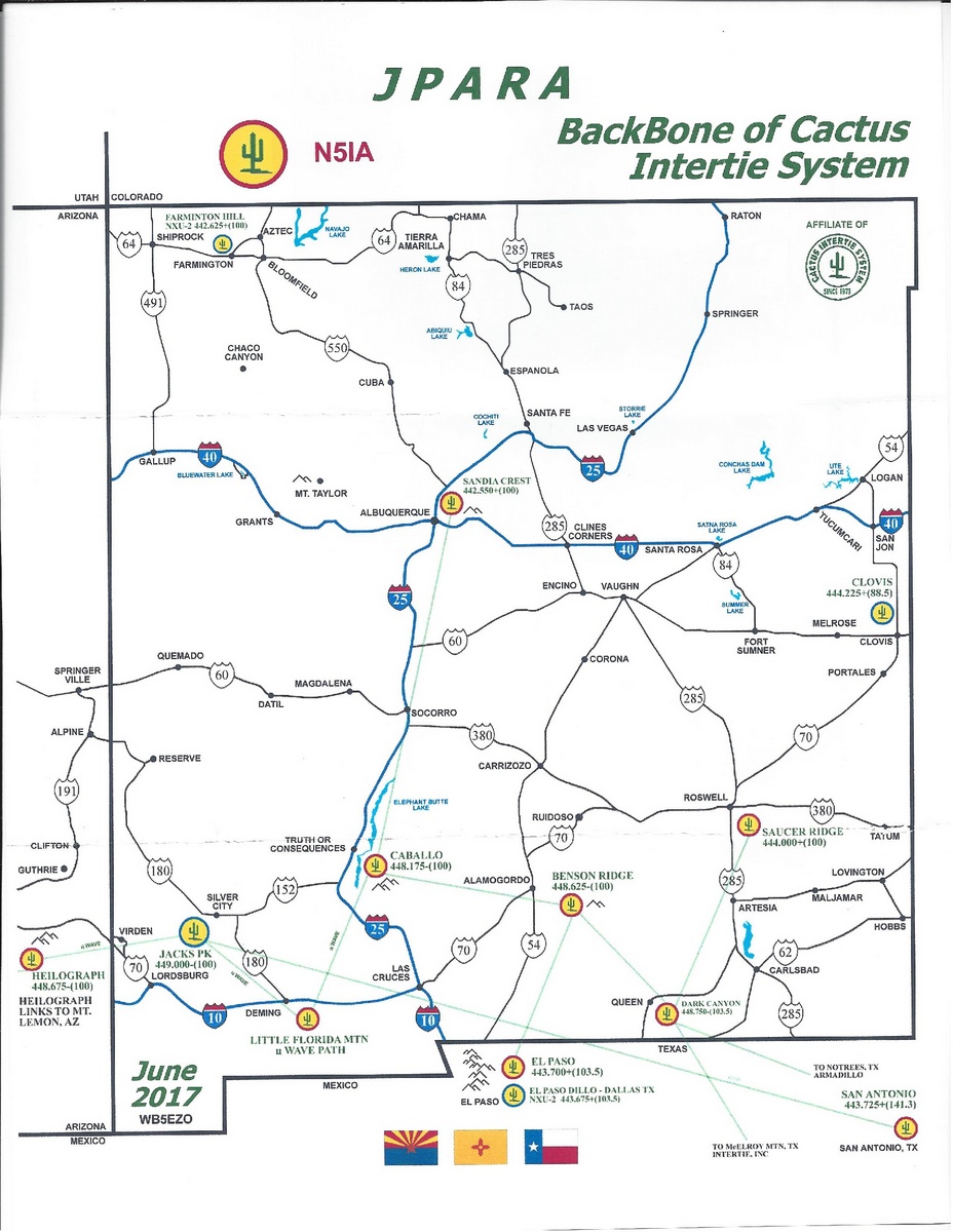
The club owns and operates an extensive network of linked radios, and
remote base stations, most of which are located high on mountain tops.
Traditional UHF full duplex, Microwave and ROIP
(Radio Over Internet Protocol) links are used to link the system.
Our Backbone sites are more that just repeaters. They are actually "REMOTE BASE"
stations. They are connected to a very complex controller, usually either a Palomar or Sierra
Control Systems device. Unlike some of the other systems where the links are
hard connected, our link are totally controllable. By FCC rule, the Remote base
designation requires that every operator has to be a control operator of the system.
This takes a fair amount of training, and because of this our system is
considered a "MEMBERS ONLY" system
The club is comprised of members from throughout the state of New Mexico and
far West Texas. Members come from a variety of backgrounds, some directly
related to the radio field, and some not. There is a wealth of technical
information available for the asking, or just a "good afternoon".
The Club callsign - N5IA
This club was originally issued the FCC callsign of WB5QHS. Through some
"creative licensinng", Milt and the club also had several other vanity calls, such as
K5SAN for Sandia Crest, K5BEN for Benson Ridge, and K5CAB for Caballo Peak.
There was a problem with this, though. Over the years, FCC Part97 had changed
and clubs were no longer allowed to do this. Existing licenses were grandfatherd
in, but with Milt's passing, this was no longer the case. We were forced to comply with the
modern standards.
With Milt's untimely passing, the club wanted to honor his memory. After a
series of email discussions, the Board agreed to pursue a single call concept.
After talking with Millt's family, the club was given permission to obtain
his callsign, N5IA in memorial. All of the existing vanity calls had to be cancelled,
except the QHS call. Then, working through both the FCC and the ARRL CLUB branch,
all of the necessary re-licensing was completed. The FCC issued N5IA back to
the club that Milt loved so dearly.
Now, when you hear the ID on the system, you will be forever reminded of Milt's presence.
Contact the Club Officers:
Sean KD6CUB - President - kd6cub@arrl.net
Martin WB5LJO - Vice-president - wb5ljo@k5wph.org
Pete - KA7VYH - Treasurer - mhamilton1961@gmail.com
Larry - N5BG- Secretary - lgriggs@aznex.net
Page last updated by Greg, KD5OH on 04/07/2024